Abstract:
The Ganges water dispute has been resulted from the construction of Farakka Barrage by India and its operation in sharing the dry season flows since 1975. As per a Temporary Agreement in 1975 between the two riparian countries decision was made to run the feeder canal only for short duration. But, there were unilateral withdrawals to the full capacity of the Barrage and diversions of the Ganges water towards upstream by India created a severe reduction in the dry season flows in Bangladesh. Again, during 1977 Agreement due to unauthorized diversions of the Ganges water in the upstream caused a drastic fall in the dry season flows below Farakka point in the NW region. The long 30 years Ganges Water Treaty from 1996 – 2026 has been made between the two countries with a condition of sharing the Ganges water equally. But, unauthorized withdrawal of water in the upstream of Farakka deprived the due share to Bangladesh causing the lowest ever dry season flows in the North West (NW) & South West (SW) regions. A drought flow study was carried out based on statistical probability analysis using historical data for the period of 1934 – 1971 (i.e. Pre- Farakka Period ). From such a study conducted during 1987 drought flow magnitude with 2%, 5% and 10% values were compared with the historical minimum flows during 1975 – 1983 (i.e. Post- Farakka Period). It was found that the Ganges flows in dry season at Hardinge Bridge point had been always remarkably lower than the estimated 10% drought values ( 1420 cumec ) and also 5% drought values ( 1290 cumec ). The continuous reduction of the dry season flows due to Farakka Barrage resulted severe effects on the hydrological regime of the Ganges and availability of surface water and groundwater within the NW and SW regions in Bangladesh. The most seriously affected sectors are; Agriculture, Fishery, Forestry, Navigation, Salinity Intrusion, Sedimentation, Soil & Water Quality, Socio-economic Life and the Environment in Bangladesh.
1. Introduction: The Ganges is one of the major rivers in the world. It originates from Gangotri situated at an elevation of 7010 m in the Himalayan Range. Nepal, India and Bangladesh are the co-riparian countries of the Ganges. The river Bhagirathi-Hoogly on which the port of Calcutta of India is situated takes off from the south bank of the Ganges. Then the Ganges river enters into Bangladesh through Farakka point which is 17.7 km upstream from the border. After the river enters Bangladesh, it flows for another 113 km before joining the river Brahmaputra- Jamuna at Goalando. Below Farakka , there are only two tributaries joining the Ganges both from the left; . those are the Mahananda and the Atrai rivers. Then the combined course of the Ganges and the Brahmaputra-Jamuna taking the name of the Padma joins lower down another river namely, the Meghna at Chandpur. The length of the Ganges from Gangotri to Chandpur is about 2527 km. From this point the combined course of the three rivers flows as the Lower Meghna towards south into the Bay of Bengal.
The Ganges river system serves about 37% of total area of Bangladesh where nearly one-third population (50 – 60 million) of the country live. There is about 3.6 million ha of cultivable land available within the Ganges basin. The Ganges water was available for agriculture, fisheries, navigation, domestic & municipal water supplies and the maintenance of delicate ecological balance of the ‘Sundarbans’ – the largest Mangrove forest of the world. The Ganges and other major rivers of the country have highly seasonable flows. Nearly 80% of its annual flow takes place during the months of July to October. About 84% of the rainfalls in the Ganges catchment also occur from June to September. Bangladesh has, therefore, too much water during the monsoon from June to October and too little during the dry season from November to May. Such acute problems in respect of low flows of the Ganges has become critical after the diversion of its water started at Farakka Barrage since its operation from April, 1975 ( Abbas, B. M. 1984 ).
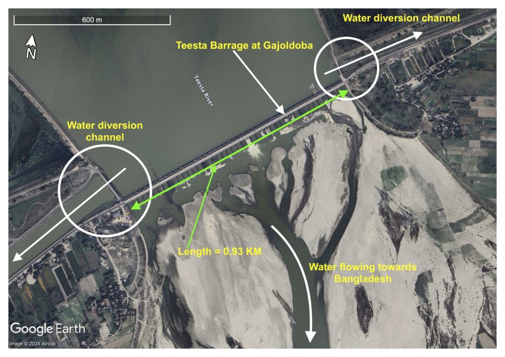
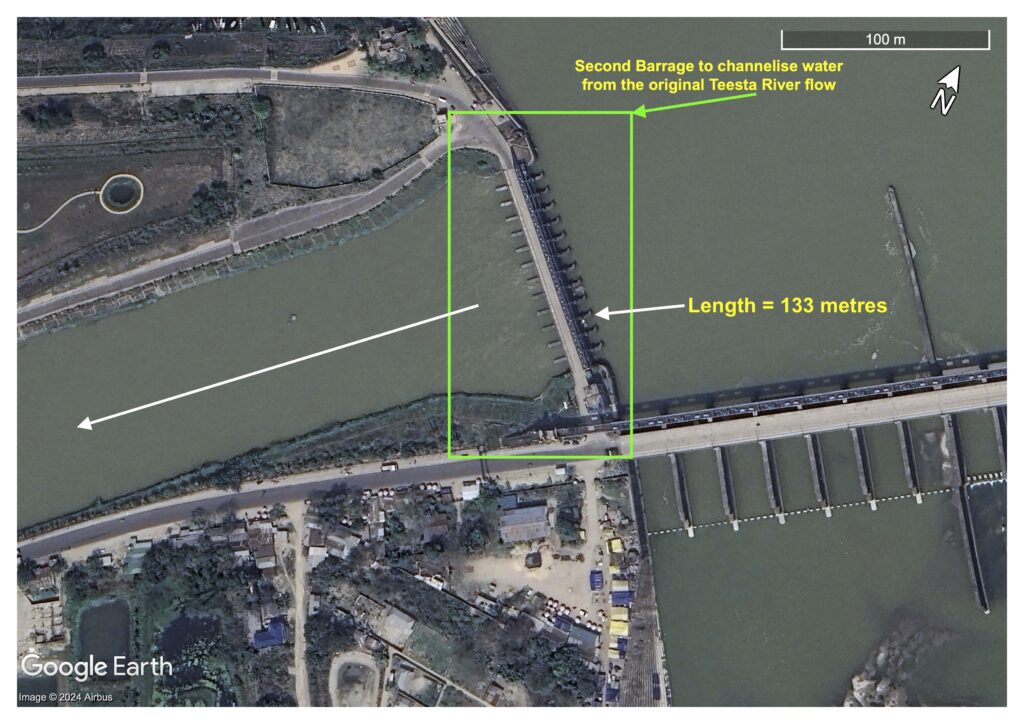
2. Ganges Water Disputes: The dispute over the sharing of the Ganges water between India and Bangladesh arose immediately after commissioning of the Farakka barrage in 1975 which has been constructed at about 17 km upstream from the western border of Bangladesh. India diverted a large quantity of Ganges flows in the upstream during the lean period starting from November to May which created serious effects on the ecosystem in the downstream region affecting the interest of Bangladesh. On the other hand, during monsoon season due to continuous opening of all of the gates of the Barrage much of the water flows into the downstream Ganges river within Bangladesh and runs wastefully to the Bay of Bengal. During the monsoon season such upstream flows along with the heavy rainfalls cause devastating floods within the Ganges catchment in Bangladesh almost in every year. So, Bangladesh Government has been trying to devise an interim arrangement with India, the upper riparian country in order to stop the damages being caused by both dry and monsoon season flows of the Ganges before going for a permanent arrangement. However, both the countries agreed to deal with twin issues – the immediate sharing of the Ganges dry season flow at Farakka and the taking of steps to augment that flow to meet their requirements simultaneously ( Islam, 1987 ).
There was a Temporary Agreement between Bangladesh and India to run the feeder canal of the Barrage for 41 days only from 21 April to 31 May, 1975. But, India continued to withdraw water unilaterally to the full capacity of the Barrage and the diverted amount of water was 75% of the dry season flow of the Ganges. This led to a critical situation in Bangladesh during of 1975-76. On the 23rd March, 1976 the water level came down to about 5 m at the Hardinge Bridge point compared to an average of 6.7 m at that time of the year. The minimum discharge reached a record low of 651 cumec as compared to the normal average of 1812 cumec which affected the GK Irrigation Project, inland navigation, fishery and also salinity intrusion in Khulna region. During the 1977 Agreement India implemented several irrigation projects and unplanned diversion of the Ganges water in UP and Bihar States resulting drastic fall in the in dry season flows below Farakka causing the highest drought condition in the North West ( NW ) region of Bangladesh ( Abbas, B. M. 1984 ).
The Ganges is one of 54 rivers shared by India & Bangladesh. The long standing disputes over the sharing of Ganges water were assumed to be resolved with the signing of the 30 Years Ganges Water Treaty in December, 1996 which will continue until end of 2026. Under the terms of the Treaty both India & Bangladesh share the water equally. This subject to the condition that both India & Bangladesh will receive guaranteed 991 cumecs (35,000 cusecs) in three alternate 10-day periods between March 11 to May 10 in every year. But, in the dynamic context of climate change and unauthorized withdrawal of water from the main Ganges River in the upstream of Farakka by some diversion channels has deprived the due share of Bangladesh. During the last few years people living in the NW & SW regions of Bangladesh have been experiencing the lowest ever river flows during dry season ( Sarker, 2024 ).
3. Ganges Drought Analysis: In analysis of drought magnitude the minimum discharge i.e. low-flow within a specified time period is considered which may be one day, one week or one month depending on the river catchment situation and nature of water uses. In analyzing the drought flow the use of statistical distributions have received much attention since 1960s. For this purpose there have been reports on the use of either 2-parameter or 3-parameter probability distributions (Joseph, 1970 ). In Bangladesh very limited research works have been conducted on drought analysis of the river flows. Since the Ganges is a trans-boundary river and one of the largest surface water source within the NW & SW regions of the country, the magnitude of its dry season flow is of prime importance for surface water utilization.
Exact magnitude and duration of the Ganges droughts are very important for direct perennial supply of water for irrigating agricultural lands, fisheries, navigation, pollution and salinity control, and river flow regulation, etc. Due to the effect of withdrawal of the Ganges water at Farakka point in India by constructing a Barrage, it is very important to know the magnitude of low-flows at the downstream. Khan & Rahman (1987) conducted a study for the Ganges river flow based on the historic monthly minimum flow series measured at Hardinge Bridge ( Station No. 90 ). Both the maximum and minimum monthly discharge data for the period of 1934 to 1985 were collected from Bangladesh Water Development Board (Surface Water Division). In order to avoid the effect of withdrawal of the Ganges water by India, monthly stream flow data prior to the operation of the Farakka Barrage ( i.e. 1934 to 1971 ) was considered for drought flow analysis. From the group of statistical tests it was confirmed that the 2 – Parameter Log – Normal distribution was the best for probability method of low- flow data analysis. On the basis of graphical representation of the distributions the drought flow magnitude with 2%, 5% & 10% probabilities of non – exceedence were obtained as 1100 cumec, 1290 cumec and 1420 cumec respectively. Again, the drought flows of the Ganges for the mentioned design criteria for Log- Normal distribution were compared with the historical minimum flows during 1975 – 1983 ( i.e. Post – Farakka period ). It was found that during the above mentioned study period the dry season flows at Hardinge Bridge point had been always remarkably lower than the estimated 10% drought values ( 1420 cumec ). It was also found that the Ganges flows in the months of dry season during 1975 – 1983 were even below than 5% drought value ( 1290 cumec ) except the year of 1978.
4. Effects of Farakka Barrage on the Ganges Flow : The effects of Farakka Barrage on the Ganges flow has caused various natural disasters within the NW and SW regions of Bangladesh which are mentioned below:
a. Surface Water: Natural flow regime of the Ganges ( the Padma ) has been changed due to unilateral withdrawal by India causing a marked reduction in dry season flows. In April, 1976 the Ganges flows amounted to only 23,200 cusec ( 657 cumec) at Hardinge Bridge point compared to the normal pre- Farakka flows of about 65,000 cusec i.e 18,405 cumec ( Asafuddowlah, 1998 ). Under the terms of Ganges Water Treaty 1996 both India & Bangladesh will receive guaranteed 35,000 cusec ( 991 cumec ) in three alternate 10-day periods between March 11 to May 10 in every year. But, in the dynamic context of climate change and unauthorized withdrawal of water from the main Ganges River in the upstream of Farakka by some diversion channels has deprived the due share of Bangladesh. During the last few years people living in the NW & SW regions have been experiencing the lowest ever river flows which has reduced to less than 10,000 cusec ( 283 cumec) during the dry season. Unfortunately this Treaty has not been followed by the upper riparian country any time over the years.
b. Groundwater: Aquifers within the NW & SW regions are annually replenished by the Ganges flows. Since duration of flows are controlled at the upstream point, time of replenishing the aquifers becomes less and can not be fully recharged. The groundwater in these regions have faced adversities in term of:
i} Sharp fall in the river stage causing steep groundwater gradient towards the river resulting in fast lowering of the groundwater level, leading to a continuous depletion of aquifers in the regions.
Ii} Degraded quality of groundwater due increased concentration of Total Dissolved Solids (TDS) affecting agriculture, industry, domestic and municipal water supply and the soil quality over the basin area.
iii) The other resultant effects are: Lowering of static water levels in Shallow Tubewells & Hand Tubewells resulting high pumping costs, and also saline water intrusion in the STWs installed near the river banks.
c. Sedimentation: Due to flashing of sediments through Farakka Barrage every year during monsoon about 15 million tons of silts are deposited in the Ganges tributaries. This has caused excessive siltation, rise of the river bed levels and consequent reduction in the conveyance capacity of the channels of the off take of the Gorai river. So, due to massive siltation there has been built up of many sand islands on the mainstream of the lower Ganges.
d. Agriculture: Agriculture is the worst hit sector due to the Farakka Barrage and the effect of the Ganges flow reductions over the years in this sector is multitudinous. The Ganges basin covers 19 districts in the NW & SW regions where the main occupation of the people is agriculture including crops, livestock and fisheries. The affected region has experienced both direct and indirect losses due to diversion of water in the upstream in these areas during the entire post Farakka period since 1976. Agro-ecology, biodiversity, rural livelihood and the environment of these regions have been greatly affected due to drastic reduction of the Ganges flows during dry season. The largest Surface Water Irrigation Scheme in the country, namely GK Project, has already been abandoned due to lack of surface water inflows from the Farakka point. This Project was solely based on the Ganges water and designed with a command area of 0.121 Million ha within 4 districts of SW region of the country during 1960s. After 1975 there has been major adverse impact on the overall performance of the project due to restricted flows from the Farakka point. About 1 km long Charland with sandbars has been raised just at the mouth of intake channel to pump water. The Kapotakkha river which was mainly used as irrigation channel of the Project has already been completely dried up.
e. Navigation: The reduction of the Ganges flows have made more than 320 km of navigable routes completely inoperative during the dry months. Inland transport which is the easy communication for people and the cheapest way of carrying goods within the riverine way within the Ganges basin has been drastically reduced.
f. Salinity Intrusion: The salinity problem has increased in the SW region as a result of reduced fresh water flows during dry season from the upstream of the Ganges. The salinity of Khulna area shot up from 380 micromhos of the pre- pre-Farakka period in 1974 to more than 26,000 micromhos in April, 1992. The salinity front has moved inland significantly. The salt water front has already encroached up to Madhumati and Gorai rivers. The salinity problem has also adversely affected the availability of potable water and the required irrigation water in the SW region.
g. Climate Change: Bangladesh is already a vulnerable country in the context of climate change. The Ganges basin within the country becomes more vulnerable in the context of climate change where effects may result more severe droughts, floods and natural disasters (storm, cyclone, tidal surge).
h. Cross-cutting Issues: Apart from the aforesaid sectors, some cross-cutting issues of the adverse impacts of reduction of the Ganges flows have been identified for the SW & NW regions. These are: Degradation of Mangrove Forests, Arsenic Pollution, Degradation of Soil Quality and Desertification in the NW region of Bangladesh.
5. Conclusion :
The Ganges, one of the largest rivers of the world, plays a very crucial role in the sustenance of livelihood of more than 50 million people in the NW and SW regions of Bangladesh. The commissioning of the Farakka Barrage by India gave rise to the problem of sharing dry season flows of the Ganges and originated the on-going river water disputes between the two riparian countries – India and Bangladesh. Though there was a Temporary Agreement between the two countries in 1975 about sharing of Ganges water, but India continued to withdraw unilaterally the full capacity of the Farakka Barrage diverting less than the required dry season flow towards Bangladesh. Again, during the 1977 Agreement India had unplanned diversion of the Ganges water in upstream resulting drastic fall in the dry season flow causing the critical drought condition in the NW region of Bangladesh. In the last “Thirty Years Ganges Water Treaty” from 1996 to 2026 where both of the countries are supposed to share the Ganges water equally; but due to dynamic climate change and unilateral withdrawal of water by India has deprived the due share of the Ganges water to Bangladesh where the NW & SW regions have been experiencing the lowest ever dry season river flows.
Exact magnitude and duration of the Ganges drought is very important for direct perennial supply of water. So, a drought flow analysis was carried out based on statistical probability using historical data for the period of 1934 – 1971 (i.e. Pre- Farakka period ). From such a study conducted during 1987 drought flow magnitude with 2%, 5% and 10% values were compared with the historical minimum flow during 1975 – 1983 (i.e. Post- Farakka period). It was found that the Ganges flows in dry season at Hardinge Bridge point had been always remarkably lower than the estimated 10% drought values ( 1420 cumec ) and also 5% drought values ( 1290 cumec ). The drastic reduction of the dry season flows due to Farakka Barrage resulted severe effects on the hydrological regime and morphological behavior of the Ganges and its tributaries within the NW and SW regions in Bangladesh. The most seriously affected sectors/areas are: Availability of Water Resources- both Surface Water & Groundwater; Agriculture; Fishery; Forestry; Navigation; Salinity intrusion; Sedimentation; Soil & Water Quality; Socio-economic Life and the Environment in Bangladesh.
References :
- Abbas, B. M. A. T. ( 1984 ). The Ganges Water Dispute. The University Press Limited, Dhaka.
- Asafuddowlah ( 2003 ). Impacts of Farakka. National Documentation on the Problems of Arsenic and Farakka. International Farakka Committee, INC, New York, U.S.A.
- Begum, Khurshida ( 1987 ). Tension Over the Farakka Barrage – a techno-political tangle in South – Asia. The University Press Limited, Dhaka.
- Islam, M Rafiqul ( 1987 ). Ganges Water Dispute – Its International Legal Aspects. The University Press Limited.
- Joseph, E. ( 1970 ). Probability Distribution of Annual Droughts. Journ. of Irrig. & Drainage Div. Proc. ASCE, IR – 4, Paper No. 7727. U. S. A.
- Khan, L. R. & Rahman, F. ( 1987 ). Estimates of Drought Flows of the Ganges. Bangladesh Journ. of Agricultural Engineering, Vol. 1. No. 2, July.
- Sarker, R. H. ( 2024 ). India, Bangladesh Prepare to Renew Ganga Treaty. Hindustan Times, 05 July.
- This article is written by Lutfor Rahman Khan. The Author is a Retired Professor of Bangladesh Agricultural University. After graduation in Agricultural Engg, in 1972, he completed M. Eng degree in Water Resources from AIT, Bangkok in 1976. Later, he completed Ph.D from Civil Engg. Dept. of Univ. of Newcastle Upon Tyne, U.K. in 1983 and Post-Doctorate in 1993. He also worked as a Visiting Fellow in Hydrology at Kyoto University, Japan in 1988. In addition to teaching & research, he has long experience of Consultancy Services in UNDP, FAO, JICA & the Govt. of Bangladesh in different Projects related to Irrigation, Groundwater, Water Resources Development & Management.
[Disclaimer: The views and opinions expressed in this article are those of the author solely and do not necessarily reflect the website owner, Dr Bayes Ahmed. Bayes or anyone else, except the author, does not assume any responsibility for any issues, inaccuracies, or consequences resulting from the use of information in this article.]