Bangladesh’s water security

WE CAN use the term ‘hydrocide’ — short for hydrological genocide — to describe the deliberate manipulation of water resources in ways that systematically undermine the survival of vulnerable populations. Nowhere is this concept more evident than in the context of India and Bangladesh, where large-scale water diversion projects and dam constructions have placed Bangladesh in a precarious situation, threatening its water security, livelihoods and ecological balance.

A lifeline at risk

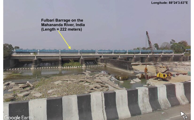
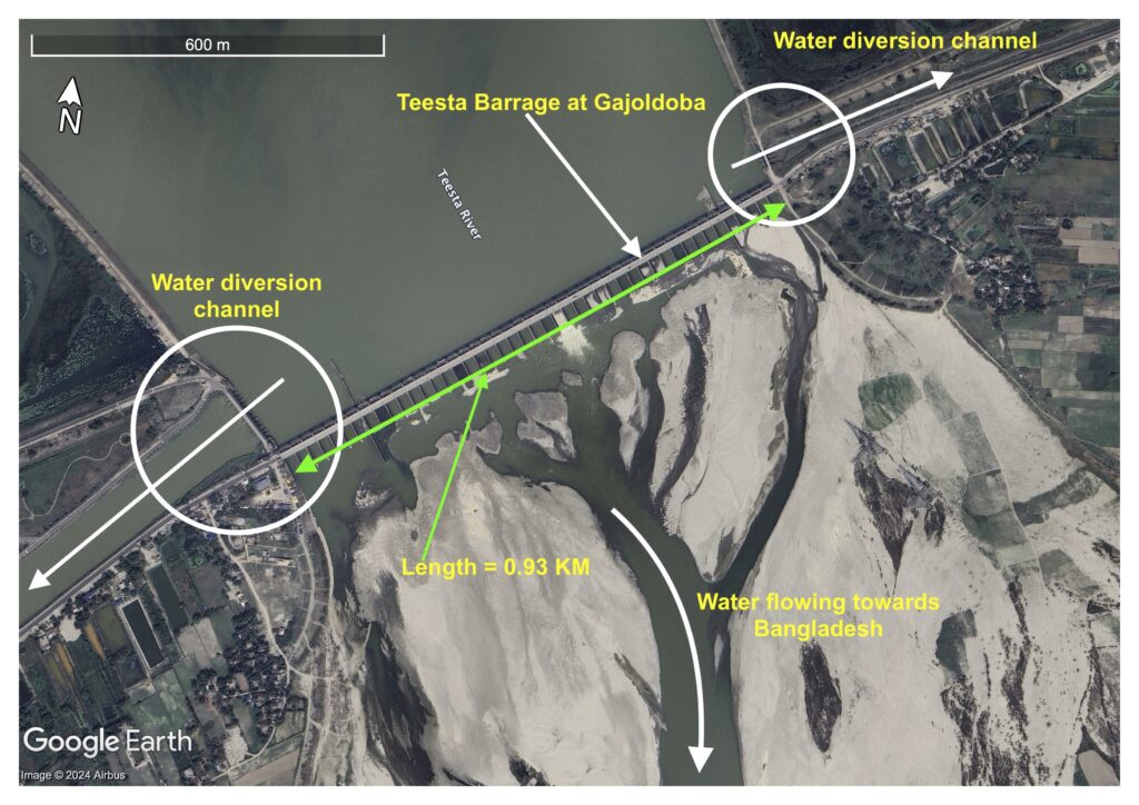
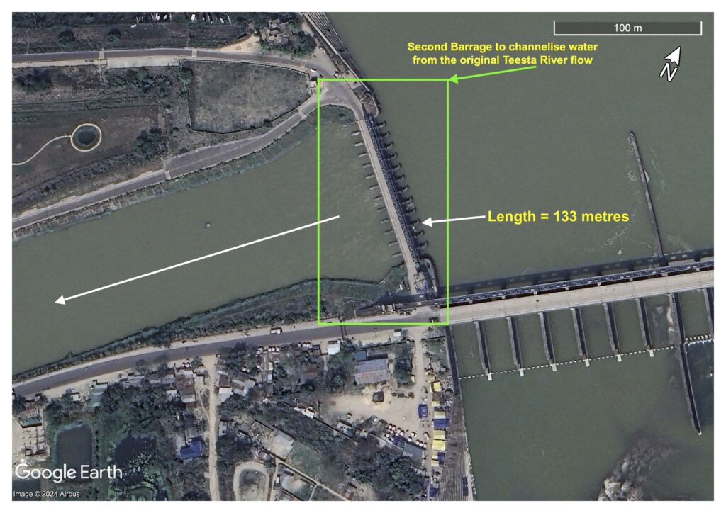
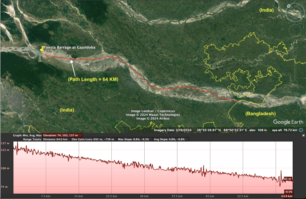
BANGLADESH, a downstream country, relies heavily on the more than 50 transboundary rivers that flow from India to sustain its agriculture, fisheries and daily water needs. Rivers like the Teesta and the Mahananda are critical to the livelihoods of millions of Bangladeshis, but the construction of dams, barrages and water diversion structures on the Indian side has drastically reduced the flow of water into Bangladesh. The proximity of these projects to the Bangladesh border raises concerns about deliberate water control and mismanagement that severely impact Bangladesh’s ability to access this vital resource.

Water disputes: dry season droughts and monsoon floods

THE effects of these interventions are felt most acutely during the dry season, when the flow of rivers such as the Teesta is significantly reduced, leading to widespread water shortages. Farmers are forced to rely heavily on groundwater extraction to irrigate their crops, causing severe groundwater depletion. Decreased river flow also leads to increased salinity in coastal areas, which harms ecosystems, reduces agricultural productivity and further threatens food security.

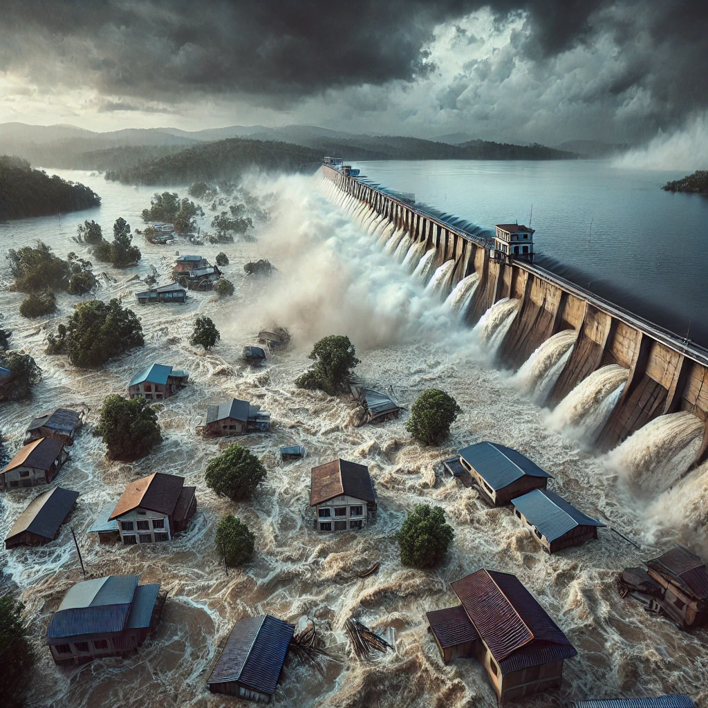
On the flip side, during the monsoon season, the sudden release of water from upstream dams often triggers devastating floods in Bangladesh. These artificial floods destroy crops, displace communities, and erode riverbanks, destabilising both the environment and the livelihoods of those living near the rivers. The unpredictable management of water flow creates a dangerous cycle of droughts and floods, leaving Bangladesh vulnerable to constant water crises.

Environmental justice and the power imbalance

FROM an environmental justice perspective, India’s hydrological policies represent a profound injustice. Bangladesh, as a downstream nation, has little say in how these transboundary rivers are managed, despite bearing the brunt of the impacts. India’s construction of large water infrastructure projects without meaningful consultation or data sharing has led to serious human rights concerns, as these decisions disproportionately affect the most vulnerable communities in Bangladesh.

The lack of an effective joint river commission or early warning systems further exacerbates the problem, leaving Bangladesh ill-prepared to manage the sudden influx or reduction of water. International human rights standards emphasise equitable access to natural resources, yet India’s actions challenge this principle, raising the question of whether ‘hydrocide’ is a form of indirect oppression.

Hydrocide: A case for genocide?

THE concept of ‘hydrocide’ gains even more weight when considered through the lens of the 1951 Genocide Convention. If it can be proven that the control of water resources is being used with the intent to harm or destroy a significant portion of Bangladesh’s population, such actions could theoretically be classified as genocidal. By depriving Bangladesh of essential water resources and undermining the conditions necessary for survival, India’s water management policies could be seen as inflicting harm on a national group, which falls under Article II(c) of the Genocide Convention.

However, proving intent and demonstrating that these actions are deliberately targeting Bangladesh as a national group remain significant legal challenges. While the immediate impacts of water shortages and floods are evident, the long-term consequences of such policies — especially in the context of climate change — could lead to even more severe outcomes, such as forced displacement and migration, economic collapse and ecological destruction.

The path forward: collaboration and equity

THE water crisis between India and Bangladesh is not just a bilateral issue — it is a matter of regional stability and environmental justice. Without equitable water-sharing agreements and collaborative river management, the situation is poised to worsen, with far-reaching consequences for both nations.

A sustainable solution requires India and Bangladesh to establish meaningful dialogue, backed by transparent data sharing and joint efforts to manage their shared water resources. The UN Water Convention and international legal frameworks provide guidance for resolving transboundary water disputes, but the political will to adhere to these principles is crucial.

Ultimately, addressing the root causes of this crisis requires recognising that water is not just a resource but a lifeline. As the world faces the mounting pressures of climate change and population growth, cooperation between nations on issues of water security will be key to preventing future conflicts and ensuring the survival of millions who depend on these rivers for their livelihoods.

Original source: This article was first published in New Age on 28 September 2024.

Diverted Destinies: The Teesta-Mahananda Barrages and Bangladesh’s Water Crisis

India’s construction of barrages and water diversion structures along the Teesta and Mahananda rivers creates a significant transboundary water crisis for Bangladesh.

This first image shows the Teesta Barrage at Gajoldoba, West Bengal, India. It highlights two major water diversion structures (east and west) on either side of the barrage. Water is being diverted from the Teesta River towards canals that lead to different regions in India, particularly the Dakshin Hanskhali area on the east and the Teesta-Mahananda Link Canal on the west. A smaller portion of water continues to flow downstream towards Bangladesh, which is already significantly reduced.

The second figure shows the path of the Teesta Mahananda Link Canal, a canal stretching 26.7 kilometres from the Teesta Barrage to the Fulbari Barrage (Latitude: 26°38’41.95″N and Longitude: 88°24’3.63″E) on the Mahananda River. The diversion canal is meant to redirect water from the Teesta River into the Mahananda River for use in India, effectively limiting the natural flow into Bangladesh.

This image above focuses on the Fulbari Barrage on the Mahananda River, located just 1.55 kilometres away from the Bangladesh border. Water from the Teesta River is being funnelled into the Mahananda River through the Teesta Mahananda Link Canal. This diversion reduces the water flowing into Bangladesh from the Teesta and Mahananda rivers. The image also shows water being diverted westward towards other regions of India.

A close-up image of the Fulbari Barrage reveals more details about the inlet water diversion structure, which channels water from the Mahananda River towards the Dahuk River in India. Water flowing towards Bangladesh is marked as being just 1.5 kilometres away from the barrage. This proximity demonstrates how close the barrage is to Bangladesh’s border, affecting the country’s water security.

Summary: The images and water management practices depicted reveal a clear case of environmental injustice and hydrological domination. Bangladesh suffers from severe water shortages due to the diversion of transboundary rivers, leading to ecological degradation, livelihood destruction, artificial flooding, and economic instability. To tackle these issues, it is crucial for India and Bangladesh to establish more equitable water-sharing agreements, backed by the UN Convention on the Law of the Non-navigational Uses of International Watercourses, and transparent and cooperative management practices. Without such measures, the water crisis in Bangladesh will continue to intensify, threatening the livelihoods of millions of people in the region.

Teesta Barrage at Gajoldoba, India

The images below illustrate water diversion and damming activities along the Teesta River at Gajoldoba (Latitude: 26°45’14.36″N and Longitude: 88°35’23.80″E), affecting water flow from India into Bangladesh. Let me explain each figure based on the visible descriptions:

Figure 1: Teesta Barrage at Gajoldoba, India. Imagery date: 08 April 2023. Source: Google Earth Pro.

Figure 1 shows the Teesta Barrage located at Gajoldoba. The water diversion channels on both sides of the barrage are clearly marked, which redirect water from the main river flow. There is a visible portion where water is still allowed to flow downstream towards Bangladesh, but a significant amount of water is being diverted before reaching Bangladesh. The length of the barrage is noted as 0.93 km. The diversion of water reduces the natural flow of the river downstream, contributing to reduced water availability in Bangladesh, particularly during the dry season.

Figure 2: Inlet water control structure at the Teesta Barrage, diverting water towards the Mahananda River in the west of India. Imagery date: 08 April 2023. Source: Google Earth Pro.

Figure 2 depicts a secondary structure, measuring 133 meters in length, known as the inlet or water control gate, that channels water from the natural flow of the Teesta River. A white arrow highlights the diversion of water towards the Mahananda River in the west via a 26.7-kilometer artificial channel. This illustration demonstrates how water is redirected before it can proceed towards Bangladesh.

Figure 3: Inlet water control structure at the Teesta Barrage, diverting water towards Hanskhali and Majhgram areas in the east of India. Imagery date: 08 April 2023. Source: Google Earth Pro.

Figure 3 displays another water control structure, 48.50 meters in length, designed to further control and divert water from the Teesta River to the eastern region of India. This barrage redirects water away from its natural course, indicating a compounded reduction in water availability for downstream areas in Bangladesh.

Figure 4: The Teesta barrage overview with path length. Imagery date: 08 April 2023. Source: Google Earth Pro.

Figure 4provides a larger geographical view of the Teesta River, marking the Teesta Barrage at Gajoldoba. The path length of water diversion is shown as 64 kilometres from the barrage towards Bangladesh. The lower part of the image shows an elevation profile of the river path, demonstrating the gradual decrease in elevation (from 130 to 82 metres) as the river approaches Bangladesh. The diversion of water upstream exacerbates water shortages downstream, particularly in Bangladesh, where the river flow diminishes after multiple diversions.

Summary of the Figures

These images together highlight the extensive water management infrastructure (barrages and water diversion channels) constructed by India on the Teesta River. The cumulative effect of these structures is the reduction of water flow into Bangladesh, particularly during critical agricultural seasons. The figures emphasize how close these infrastructures are to the Bangladesh border, raising concerns about the equitable sharing of transboundary water resources.